内蒙呼集高速公路丰山营段设计(含CAD图)(任务书,开题报告,外文翻译,论文计算书13000字,CAD图纸13张)
摘要
本设计为内蒙古呼集高速丰山营段的设计,设计道路等级为高速公路,说明书详细解释说明了整个设计的过程、各项参数的选取,道路所在地的详细情况、参考依据、以及各个参数的计算。
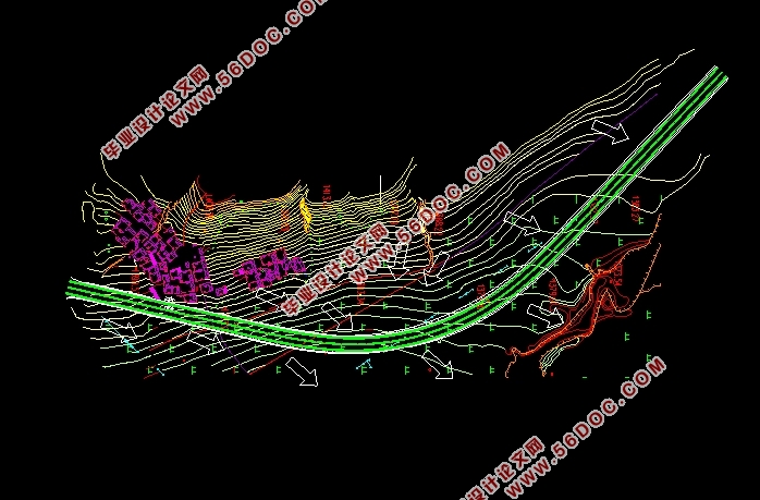
首先根据交通量进行道路等级的论证选取设计车速以及设计车道数,然后进行选线设计,对两条不同的路线进行比选,确定最佳路线,之后对该路线进行横纵断面设计以及路基设计。设计后半部分为路基挡土墙设计以及道路路面结构设计,挡土墙所给资料为重力式路堤墙,详细计算了挡土墙各项参数,并对挡土墙强度及其稳定性进行验算。路面工程部分拟定了两种不同的沥青混凝土路面方案,对两种方案进行了路面结构设计并且验算了其各项参数。最后一章为桥梁涵洞设计,本路段无跨河所以无需设置桥梁,在沟壑处设置了4个涵洞用来排水。
关键词:交通量;高速公路;道路等级;平曲线;竖曲线;路基路面;支挡结构;排水设计;沥青路面;
Abstract
This design is the design of the Fengshanying section of Huji Expressway in Inner Mongolia. The design road grade is a highway. The manual explains in detail the entire design process, the selection of various parameters, the details of the location of the road, the reference basis, and the calculation of various parameters.
First, according to the demonstration of the traffic volume, the design speed and the number of design lanes are selected, and then the line selection design is carried out. The two different routes are selected to determine the best route, and then the transverse and longitudinal design of the route and the roadbed design are performed. The last half of the design is divided into roadbed retaining wall design and road pavement structure design. The information given by the retaining wall is a gravity embankment wall. The parameters of the retaining wall are calculated in detail, and the strength and stability of the retaining wall are checked. In the part of pavement engineering, two different schemes of asphalt concrete pavement have been developed, the pavement structure design of the two schemes has been carried out and its parameters have been verified. The last chapter is designed for bridge culverts. There is no bridge across the river on this section, so no bridge is required. Four culverts are set up at the gully for drainage.
Keywords:Traffic volume; Expressway; Road grade; Flat curve; Vertical curve; Subgrade pavement; Block structure; Drainage design; Asphalt pavement
1.1自然条件概况
内蒙地区位于中国北部,横跨西北至东北。该地区矿产资源丰富,西部地处西北干旱区,东北部与东三省相邻,该道路位于丰山营段,属于平原微丘山区。该地区有许多沟壑,没有古老的道路,还有许多山丘,中间有村庄和麦田。
1.2所在地土壤、地质、水文情况
1.2.1土壤
该地区面积广阔,拥有多种土壤并且每种土壤有不同的土壤特性。在土壤形成过程中,存在着很强的钙质积累,并且有机质在钙的积累过程中大量积累。根据土壤形成过程和土壤性质,分为9个土纲和22个土壤类型。在九个土纲中,钙土层的分布最少。由于内蒙古东西跨度大,土壤分布在东西方向变化很大,靠近东部三省的土壤类型为黑土,西部为暗褐色土壤区。
1.2.2地质构造
内蒙古地区又称为内蒙古高原,其地区面积宽阔,其地质结构也多种多样,内部地层的发育条件十分良好并且地下岩浆活动较为剧烈,在此过程中形成了多种矿物质,因此矿产资源也十分丰富。其东部地区分布着许多火山,在大兴安岭中段位置的绰尔河与哈拉哈河之间分布着火山群,还有阿巴嘎火山群、达来诺尔火山群、乌兰哈达火山群等火山群,这些火山群又被称为新华夏系第三隆起带。
1.2.3水文气象
内蒙古地区河流较多,其中包含黄河、永定河、西辽河、嫩江等,其河流径流总流量约为4000亿立方米。高原地区湖泊较多,湖泊上有多个著名渔场,湖泊包含贝尔湖、岱海、呼伦湖等。其水资源分布大多在东部地区,西部地区为西北干旱区,水资源较少。
1.2.4地形地貌
该段路线位于丰山营段,整个路线范围内多为丘陵地区,同时有沟壑和平原分布,平均海拔1350米左右,路线起伏不大,路线东南部为平原农田区。
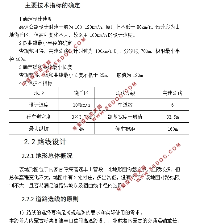
1确定设计速度
高速公路设计时速一般为100-120km/h,原则上不低于80km/h,该分段为山地微丘区,但高程变化不大,故采用100km/h的设计速度。
2圆曲线最小半径的确定
查规范可得,高速公路设计时速为100km/h时,分别取700m,极限最小半径400m
3确定缓和曲线最小长度
查规范得,缓和曲线最小长度不低于85m,一般值为120m


目录
第一章 沿线自然环境与地形地质 1
1.1自然条件概况 1
1.2所在地土壤、地质、水文情况 1
1.2.1土壤 1
1.2.3水文气象 1
1.2.4地形地貌 1
第二章 路线设计 2
2.1公路等级及主要技术标准的论证 2
2.1.1交通量分析以及等级确定 2
2.1.2主要技术指标的确定 3
2.2路线设计 4
2.2.1地形总体概况 4
2.2.2道路选线的原则 4
2.2.3路线的选定 4
2.3路线平面设计 7
2.3.1相关设计指标 7
2.3.2确定曲线要素 7
2.3.4平曲线要素计算方法 7
2.4纵断面设计 9
2.4.1纵断面设计原则 9
2.4.2纵坡设计要求 9
2.4.4竖曲线半径的设置 9
2.4.5设计步骤及方法 10
2.4.6竖曲线设计 10
2.4.7纵断面设计指标复合 11
2.5线型组合设计 12
2.5.1进行线型组合设计时需要注意的问题 12
2.5.2本方案 12
2.6主要技术指标汇总 12
第三章 横断面设计 14
3.1确定各项技术指标 14
3.2横断面设计步骤 14
3.3土方计算和调配 15
3.3.1调配要求 15
3.3.2调配方法 15
3.4路基设计 15
3.4.1路基横断面布置 15
3.4.2路基设计基本要求 16
3.4.3路基边坡 16
3.4.4路基压实标准 16
3.4.5路基防护 17
3.5路基排水设计 18
3.5.1路基排水目的和要求 18
3.5.2路基排水设计的一般原则 18
3.5.3边沟设计 18
3.5.4排水沟设置 18
第四章 挡土墙设计 19
4.1挡土墙的作用 19
4.2挡土墙的适用范围 19
4.3挡土墙的布置 19
4.4挡土墙排水设计 19
4.5沉降缝与伸缩缝 19
4.6挡土墙计算 20
4.6.1提高地基承载力的措施 20
4.6.2挡土墙的设计和计算 20
第五章 路面设计 24
5.1路面设计原则 24
5.1.1路面类型和路面结构方案设计 24
5.1.2路面设计的基本步骤 24
5.2交通组成 24
5.3路面结构设计 28
5.4材料设计参数 28
5.5路面结构验算 28
5.6方案比选 32
5.7路面排水设计 32
第六章桥梁涵洞设计 34
6.1涵洞设计原则 34
6.2涵洞设计 34
|
